
Macquarie River rafts
Information about debris rafts along the Macquarie River.
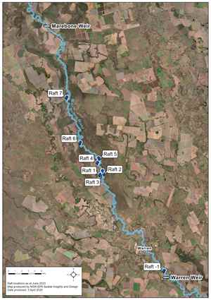
Following previous flood events in NSW, debris rafts have formed along a stretch of the Macquarie River, between Warren (Top) Weir and Marebone Weir in Warren.
The debris rafts are comprised of organic and human-derived materials.
The Environmental Services Functional Area (the EPA is the lead agency) has been working with supporting government agencies and the community as part of a coordinated environmental recovery effort.
The NSW Government held two drop-in sessions in 2023 in Warren to discuss management options for the rafts. The sessions provided feedback and insights into community concerns and the potential risks associated with rafts and proposed approaches to managing the rafts.
Following inspections in December 2023, a recommendation was made to extend the scope of the project from partial removal of two rafts to removal of human-made debris from the Macquarie River rafts between Warren (Top) Weir and Marebone Weir, including from the river shoreline. Identifiable woody weed debris, like willow, will also be removed from rafts.
The EPA has appointed a contractor to complete the works which commenced on 8 April 2024. All works are being conducted in a manner that is safe to human health and the environment.
In line with the Department of Primary Industries snag guidelines, large native woody debris over 300mm in diameter and 3m in length will be retained in the River where possible. Where necessary, retained native woody debris will be realigned to minimise the likelihood of movement and preserve important aquatic habitats.
Water monitoring upstream and downstream of rafts is being conducted during the works and immediately after the work.
Map of raft locations as at June 2023
Work is continuing on Rafts 2 and 4. Since the clean-up commenced on 8 April approximately 2,302 cubic metres of woody debris and 87.6 cubic metres of human-made debris has been removed from the Macquarie River.
Wet weather contingencies
Last week we conducted a site inspection with project contractors, Northern Rivers Marine Services (NRMS), to review access plans during wet weather events.
Following this inspection, additional access points have been identified along with Macquarie River as suitable for use during wet weather. These access points will allow us to continue work in the event that our current staging area is inaccessible due to rain.


 Work is continuing on Rafts 2 and 4. Since the clean-up commenced on 8 April approximately 1,820 cubic metres of woody debris and 82 cubic metres of human-made debris has been removed from the Macquarie River.
Snag management update
Following an on-site inspection with NSW Fisheries, natural methods will predominantly be used to secure snags as this has been assessed to be the most appropriate snag management technique for this river system.
Native timber snags will be overlapped and ‘tangled’ together to create complex snags designed to create important habitat. Larger snags combined with smaller timbers will help to minimise the likelihood of movement.
The section of the river where works are currently being undertaken, between Warren (Top) Weir and Marebone Weir, is considered low energy, meaning the risk of snags moving, when properly placed, is minimal.
This method has been used successfully in many inland rivers within NSW and throughout the Macquarie River to secure snags previously.
Large woody debris provides important habitat and shelter for native fish in the rivers of NSW. Snags are often used for breeding and resting locations and they provide shelter from predators. Snags also support other aquatic organisms that fish species use as a food source.
We look forward to answering any questions you have on the snag management plan at the upcoming drop-in session.
Despite the chilly conditions, the project contractors- Northern Rivers Marine Services are making good progress on work to remove debris from rafts along the Macquarie River. Work has now been completed on a secondary debris accumulation that was previously obstructing access, allowing work to commence on Raft 2. A sweep between Raft 1 and Raft 2 to collect human-made debris was recently conducted leading to the removal of more hard and soft plastics, metal and plastic drums, treated timber and polystyrene.
We are continuing to make good progress on Raft 4 thanks to the help of heavy machinery being used on site. Since the clean-up commenced on 8 April, approximately 1,380 cubic meters of woody debris and 45 cubic metres of human-made debris has been removed from the Macquarie River.
We welcomed an experienced representative from NSW Fisheries on Wednesday 5 June to inspect our progress and provide additional advice about snag management. Fisheries has carried out several re-snagging projects within the Macquarie River and in similar inland river systems, we are very grateful to have access to their expertise. Following the joint inspection, we are clarifying our approach to snag management and look forward to providing more information about this in future updates.
Based on progress to date we are expecting works to be completed around mid-August 2024.


Work to remove debris from the Macquarie River rafts is proceeding well. Stable weather conditions have allowed good progress to be made on Raft 4 since our last update.
Project contractors, Northern Rivers Marine Services (NRMS), are currently working on a secondary debris accumulation (SDA) that is obstructing access to Raft 2. Located between Raft 1 and Raft 2, this SDA has become more pronounced following a recent drop in water levels.
Since the clean-up commenced on 8 April, approximately 920 cubic meters of woody debris and 30 cubic metres of human-made debris has been removed from the Macquarie River. We are continuing to remove hard and soft plastics, polystyrene, chemical containers, machined and treated timber, plastic oil drums and glass bottles.
We are looking forward to Fisheries NSW joining us on-site in the coming weeks to inspect tethering options for snags. In line with the Department of Primary Industry’s snag guidelines, native woody debris over 300mm in diameter and 3m in length will not be removed entirely from the river as this timber is key to preserving aquatic habitats in the river system.


Since the clean-up commenced on 8 April, approximately 302 cubic meters of woody debris and 23 cubic metres of human-made debris has been removed from the Macquarie River.
What have we been up to recently?
A grapple and pulley system has been designed and modified, with help from an engineering firm based in Warren, to assist with debris removal. The system allows us to drag debris across the river to where it can be accessed by a long-reach excavator for removal.
Works are continuing on Raft 1 and Raft 4. A small excavator is being utilised on Raft 4 to lift material collected by boat crews in bulka bags. A boat crew continues to remove debris by hand on Raft 1.

What’s happening to debris once it has been removed from the River?
Debris is being taken to the Ewenmar Waste Depot in Warren. We recently visited the Depot to observe how debris is being managed once it arrives at the depot. It’s important that all debris collected as part of this project is managed in line with the waste hierarchy to ensure waste is managed efficiently, sustainably and safely.
The EPA is satisfied with how the Depot is managing and treating debris from this project. Ewenmar Waste Depot doesn’t currently accept debris classified as hazardous such as chemical drums. While a suitable option is being identified for hazardous waste such as chemical drums, hazardous debris is being taken to the Public Works depot in Warren.


Monitoring update
We are monitoring the Macquarie River to review water levels and flow, water quality and erosion potential at the rafts throughout this project. This monitoring is being conducted by the Science team at the Department of Climate Change, Energy, the Environment and Water (DCCEEW).
The DCCEEW Science team were recently on site to collect the data from water quality monitoring instruments located near rafts 2, 4, 5 and 7. The debris rafts are dynamic and do break up and change over time, particularly when they are floating and not anchored in place behind logs and fallen trees.
The DCCEEW Science team has confirmed that the monitoring found no evidence of any acute impacts on electrical conductivity (dissolved solids) or dissolved oxygen concentrations related to debris removal works. The monitoring instruments show that oxygen and conductivity levels remain within the normal ranges expected for the Macquarie River.

Safety is the EPA’s number one priority. Our staff supervise works on the ground, and water levels are monitored daily. If you have any concerns or questions related to the works please email us at engagement@epa.nsw.gov.au.
Since the clean-up commenced on 8 April, approximately 177 cubic meters of woody debris and 14 cubic metres of human-made debris has been removed from the Macquarie River.
Surf Life Saving NSW has now concluded their drone surveillance of the river. This valuable data will assist us in confirming the current size of debris rafts and identifying any secondary debris accumulations that we may not have been aware of previously. Works were paused briefly last week due to wet weather, but this didn’t affect the long-awaited removal of a car body deposited by the 2022 floods from the banks of the River at the Industrial Access Road Bridge just outside of Warren township.


Where have we been working?
Work has commenced on Raft 4 and near Raft 2. Heavy machinery including an excavator, a bobcat and a long-reach excavator with a 55 ft boom made their way to site last week to assist with the clean-up.

Since our last update work has continued on the removal of a variety of human-made debris from the rafts. Recent items include chemical containers, hard and soft plastics, metal and plastic drums, polystyrene, treated timber, tyres and white goods.


May Community drop-in
The 4th community drop-in session held last Wednesday 1 May was well attended by Warren community members interested in hearing about the progress of the Macquarie River raft project. We were able to let the community know that work on Raft 1 is now largely complete. As the water level changes, additional inspections will take place to determine if further work is required. We are aware of secondary debris accumulations in this area and assessment of these accumulations is ongoing.
Since 8 April when the clean-up commenced, approximately 142.6 cubic meters of woody debris and 5.3 cubic metres of human-made debris has been removed from the Macquarie River.
Debris was identified using aerial surveillance, on-ground and on-water mapping, reports from the community and reports from supporting government agencies, including the Warren Shire Council. Our contractors, Northern Rivers Marine Services (NRMS), are using multiple resources, including slings, chainsaws, boats, land vehicles and hand-picking to carry out the clean-up.
Where have we been working?
Work has commenced on Raft 1.
A scientist from the Department of Climate Change, Energy, the Environment and Water (DCCEEW) has been on site to train the contractors to identify woody weed species in debris, including willow, so they can be removed from rafts.

What types of debris have we been collecting?
We have removed a variety of human-made debris from Raft 1 including gas bottles, plastic bottles, a tyre, a hot water system, a box freezer, plastic drums, hard and soft plastics, glass, polystyrene and chemical containers. Woody debris including willow has also been removed from Raft 1.


Drone surveillance
Please be aware, you may notice drones in the vicinity of the works between 19-30 April 2024. The drones are operated by Surf Life Saving NSW and are assisting us in identifying debris in the Macquarie River, between Warren (Top) Weir and Marebone Weir in Warren.