
The ongoing impacts of water extraction and flow regulation remain significant pressures on the health of river systems but greater amounts of water are now being made available for the environment.
Demand for the state's water resources is high but is being managed through water sharing plans that balance equity of access for users, while maintaining ecosystem health.
Water sharing plans are being developed for all water sources in NSW. Since 2004, a total of 70 water sharing plans have been implemented, covering about 95% of water use, including all plans for the Murray–Darling Basin. The remaining coastal plans will be completed in 2015.
Cumulative holdings of environmental water by the NSW Government stand at around 397,418 megalitres (ML). Substantial volumes of water have also been recovered for the environment in the Murray–Darling Basin by the Australian Government, with current holdings for NSW of about 1,341,518 ML.
Over the past three years, around 600,000 ML (on average) of environmental water per year have been delivered to environmental assets in inland NSW and substantial releases made to the Snowy River with 190,000 ML released in 2013–14.
Related themes: 17 River health | 18 Wetlands | 19 Groundwater | 20 Coastal, estuarine and marine ecosystems
NSW indicators
| Indicator and status | Environmental trend |
Information availability |
|
|---|---|---|---|
| Proportion of water extraction covered by water sharing plans | |
Decreasing impact | ✔ ✔ ✔ |
| Environmental share of available water | |
Decreasing impact | ✔✔ ✔ |
Notes: Terms and symbols used above are defined in About SoE 2015 at the front of the report.
Context
Water resources are critical for many human needs, including town water supplies, domestic and stock water, the irrigation of crops, and for mining and industry. Most of these needs are satisfied by water held in storage or extracted from rivers and groundwater.
The need to maintain a healthy environment as well as securing water resources for human use and to enable economic growth depends on an adequate supply of good quality water. Water resources are needed to preserve the health of riverine, estuarine and wetland ecosystems and to maintain the food chains that support fish and other aquatic species. The health of riverine ecosystems and floodplain wetlands is discussed in Theme 17: River health and Theme 18: Wetlands, and estuaries and coastal lakes in Theme 20: Coastal, estuarine and marine ecosystems.
Water use planning must be balanced in order to meet socioeconomic demands and environmental needs, while taking into account the long-term variability in water availability due to climate extremes, such as droughts and floods. To address these needs, NSW is developing statutory water sharing plans to provide greater certainty for all water users as well as the environment. These plans, which are discussed later in this theme, aim to protect water for the environment and provide better security of entitlement for all water users.
Status and trends
Water use and sources of water
Long-term average water use in NSW is about 7000 gigalitres (GL) per year, but use is quite variable and depends on rainfall and flow conditions. Around 80% of this water is extracted from regulated rivers, where flows are controlled by large rural water storages operated by Water NSW. The remainder comes mainly from groundwater, around 11%, (see Theme 19: Groundwater), with the balance drawn from unregulated rivers.
Agriculture is the largest user of bulk water and the most variable, with overall use ranging from just under 80% when water levels are high to around 45% when they are low (ABS 2006; ABS 2010; ABS 2012; ABS 2013; ABS 2014). Water supply, which includes sewerage and drainage services, as well as water lost to evaporation and leakage during water delivery, is the second largest 'user', accounting for around 10% of total water use, followed by household use.
Water extraction
The major regulated river valleys in NSW are the Murray, Murrumbidgee, Lachlan, Macquarie, Gwydir, Namoi, Border and Hunter and they account for the bulk of water extraction in the state. Significant extraction also occurs in the Barwon–Darling River system, which is unregulated. Water from the Snowy River is stored and diverted to the Murray and Murrumbidgee rivers through the Snowy-Mountains Hydro-electric Scheme to generate electricity and supplement water extraction in those inland valleys. Water is also extracted from the Hawkesbury–Nepean for urban use in Sydney.
The relative amount of water diverted by users from regulated rivers and the water available to the environment varies from year to year, depending on the prevailing weather conditions, water availability and the flow rules in water sharing plans (see Responses section). At the beginning of each water accounting year – and periodically throughout the year – water is allocated for consumption in the regulated river valleys, according to the security of entitlement and the water resources available. Water for town supply, major utilities, and domestic and stock use has the highest level of security. Other high security licences receive a high proportion of their water allocations in all but the driest years and are typically used for irrigation of permanent plantings, such as horticulture and vines, and for industries that require an assured supply of water.
Allocations to general security licences are more variable from year to year and are mostly used for irrigating annual crops, such as cereals, rice, cotton and pastures. Depending on water sharing plan rules, general security water can be carried over from year to year, if annual allocations are not fully used. Water that is not allocated for extraction each year is considered environmental water, along with that allocated specifically to the environment through the environmental flow rules of water sharing plans and environmental water licences.
Long-term modelling of river flows and extractions
Long-term modelling of river flows based on climate and flow data for the last 120 years is used to simulate flow behaviour in regulated rivers and the impact of water resource development on the natural flows of rivers. This modelling provides a basis for setting long-term diversion limits in water sharing plans.
The models describe the variation that can be expected in river flows and the levels of water extraction over the longer term, which provides a context against which actual flows can be described and interpreted. As a general rule, the models show that the proportion of water remaining for the environment is higher during wetter periods than during drier periods. By contrast, when flows are low, there is less water available in total and a greater proportion of it is generally allocated for consumption.
Current river flows and extractions
In the decade up until 2010–11, water extractions had been gradually falling due to the severity of drought conditions. Figure 16.1 shows that the quantity of water extracted from regulated rivers rose sharply in 2010–11 as surface water availability increased following widespread heavy rains, but is now tapering off as conditions dry out across much of NSW.
The proportion of water extracted and that remaining for the environment in the major regulated river valleys of NSW is shown in Figure 16.2.
Figure 16.1: Water diverted by licensed users in major NSW regulated valleys, 1999–2000 to 2013–14
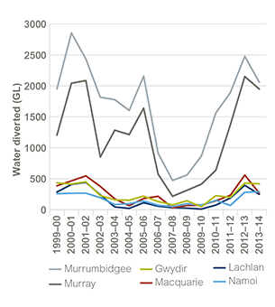
Source: DPI Water data 2015
Notes: Observed diversions are metered general security, high security and supplementary diversions.
Data for Figure 16.1
Following a wet period in 2010–11 and/or 2011–12, depending on the individual catchment, conditions are now becoming drier in most river valleys across NSW. While the proportion of water retained in river systems was relatively high during the two wet years, in the two years since, extraction levels have generally exceeded 50% of the total water available in most inland regulated river valleys.
Environmental water
To offset the impact of water extraction and flow regulation, and to maintain the health of natural systems and water resources, a share of the water resource is set aside for environmental purposes. Two types of environmental water are recognised under the Water Management Act 2000 and provided for in water sharing plans for regulated rivers in NSW: planned environmental water and adaptive environmental water.
Planned environmental water: is committed to the environment by environmental water rules in water sharing plans. This is done by limiting overall water extraction to ensure that an agreed amount of water remains in the river and applying specific environmental flow allocations or 'rules'.
Figure 16.2: Diversions and water remaining after extraction in the major NSW regulated valleys, 1999–2000 to 2013–14
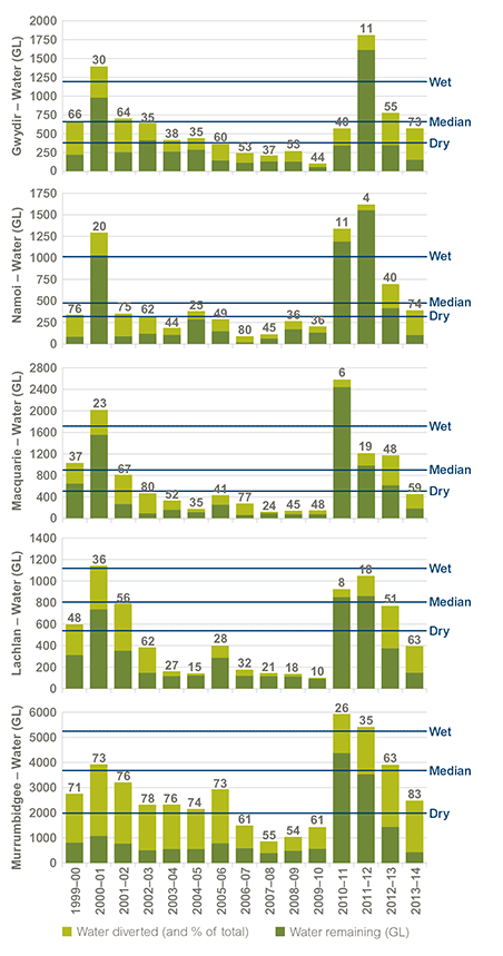
Source: DPI Water data 2015
Notes: Some of the 'water remaining' is lost to evaporation, seepage and other transmission losses. While it is in the system, it provides some benefit to the environment, depending on how long it remains and the volume and timing of the flow.
Observed diversions are metered general security, high security and supplementary diversions. Floodplain harvesting is not included and further reduces the volume of water remaining in the charts.
The data for each valley represents total water available and is taken from a representative gauging station downstream of major tributary inflows and upstream of major extractions.
Total flow and observed diversions in the Murrumbidgee Valley are influenced by water released from the Snowy Mountains Hydro-electric Scheme. In percentage terms the influence is greatest in dry years. Development in the valley reflects this inter-valley transfer.
Wet, median and dry flow levels are sourced from long-term (110-year) hydrological modelling of conditions for water sharing plans.
The typical dry year is the 80th percentile of total water available, the typical median year the 50th percentile and the typical wet year the 20th percentile. Percentile is the proportion of time the flow volume is equalled or exceeded.
Data for Figure 16.2
Adaptive environmental water: is water that is committed to the environment through water access licences. This is equivalent to 'held water' under Australian Government legislation. It is generally purchased in water markets from willing sellers or created through investment in water savings measures that convert previous water losses into an equivalent licensed entitlement. Adaptive environmental water is actively managed for specific environmental outcomes and can be used to supplement planned environmental water.
Unregulated water sharing plans generally rely on rules that limit extraction of river flows to protect a share of water for the environment. In most cases, rules set out an annual extraction limit and a low flow 'cease-to-pump' level. This threshold is intended to minimise impacts on low flows and protect water for basic ecosystem health and riparian water users.
Environmental water recovery
Water has been purchased or recovered for the environment in NSW through a number of water recovery programs by the NSW Government. This water contributes to the total NSW Environmental Water Holdings. The cumulative total for all NSW adaptive environmental water at June 2015 was 397,418 ML.
Table 16.1 summarises the collective amount of water holdings acquired by NSW from water recovery programs, by river valley. Table 16.2 describes water holdings acquired by the Australian Government.
Table 16.1: Cumulative holdings of adaptive environmental water recovered by the NSW Government to June 2015 by valley or program (ML entitlement)
| Valley/Program | NSW environmental water holdings | Total | |||
|---|---|---|---|---|---|
| High security | General security | Supplementary allocation | LTCE* | ||
| The Living Murray | 221,487 | 221,487 | |||
| Gwydir | 1,249 | 17,092 | 3,141 | 21,482 | |
| Macquarie | – | 48,419 | 1,451 | 49,870 | |
| Lachlan | 1,795 | 36,569 | – | 38,364 | |
| Murrumbidgee | – | 28,508 | 5,680 | 34,188 | |
| NSW southern Murray–Darling Basin | 2,027 | 30,000 | – | 32,027 | |
| Subtotal | 5,071 | 160,588 | 10,272 | 221,487 | 397,418 |
Source: OEH data 2015
Notes: * The Living Murray holdings are expressed as long-term cap equivalent (LTCE), which equates to the long-term water availability associated with these licences. This water is held in the Murray, Murrumbidgee and Lower Darling rivers across a range of entitlement types.
These figures do not included unregulated water holdings which are not actively managed.
Table 16.2: Cumulative holdings of environmental water recovered by the Commonwealth Government by valley (ML entitlement)
| Valley | Commonwealth environmental water holdings for NSW | Entitlement (Total) | ||
|---|---|---|---|---|
| High security entitlement |
General security entitlement |
Supplementary entitlement | ||
| Border Rivers | – | 420 | – | 420 |
| Gwydir | 4,508 | 89,525 | 20,451 | 114,484 |
| Lachlan | 933 | 86,923 | – | 87,856 |
| Lower Darling | 397 | 795 | – | 1,192 |
| Macquarie/Cudgegong | – | 126,224 | 8,292 | 134,516 |
| Murray | 15,677 | 335,035 | 211 | 350,923 |
| Murrumbidgee | 7,629 | 233,994 | 20,820 | 262,443 |
| Murrumbidgee (Lowbidgee) | – | – | 381,000 | 381,000 |
| Namoi (Upper) | – | 105 | – | 105 |
| Namoi (Lower) | – | 7,322 | – | 7,322 |
| Peel | – | 1,257 | – | 1,257 |
| Total | 29,144 | 881,600 | 430,774 | 1,341,518 |
Source: Environmental water holdings, Australian Government Department of the Environment (as at 10/8/2015)
Environmental water delivery
How much water is available to be released for the environment depends on the annual allocations available for the different entitlement types.
Table 16.3 presents the volumes of water that were released from storages in different river valleys through specific environmental allowances between 2012–13 and 2014–15, or as a result of adaptive environmental licences. It does not include water made available to the environment through fixed rules in water sharing plans, such as prescribed end-of-system flows or dam transparency releases.
Around 689,000 ML of environmental water were delivered to environmental assets in inland NSW valleys during 2012–13, 635,000 ML in 2013–14, and 452,000 ML in 2014–15.
Significant environmental water deliveries occurred in the Lachlan River basin where the Australian and NSW Governments coordinated the largest ever release of held environmental water in the Lachlan system. A total of 89,779 ML of environmental water was released over autumn to spring of 2013. The Murrumbidgee River also saw the largest release of environmental water to date, which delivered a total of 223,957 ML over 62 days, including significant contributions from the Australian Government Environmental Water Holder, the Living Murray Initiative, and NSW environmental water accounts. This release was targeted specifically to support the Murray cod breeding season and created suitable conditions for successful breeding. These water deliveries continued to build on the significant ecological responses that occurred during the two above average wet years from 2010 through to 2012.
An evaluation of the environmental water management program from 2006–13 (OEH 2015) found that the condition of wetland communities targeted for environmental watering had improved since the program commenced, due to the increased frequency or extended duration of watering events (see also Theme 18: Wetlands). While the contribution of water held under licences was modest (around 10% of all environmental water delivered) it was important in providing the flexibility to target specific priority sites or resources that cannot be met through the fixed rules in water sharing plans.
Table 16.3: Environmental water delivered in inland rivers of NSW, 2012–13 to 2014–15 (ML)
| Water source | 2012–13 | 2013–14 | 2014–15 | |||
|---|---|---|---|---|---|---|
| EWA | AEW | EWA | AEW | EWA | AEW | |
| Gwydir | 3,074 | 48,074 | 1,000 | 31,915 | 29,880 | 50,894 |
| Macquarie | 128,063 | 137,718 | 43,675 | 20,985 | 19,117 | 16,037 |
| Lachlan | – | 66,656 | – | 23,123 | – | 6,433 |
| Murrumbidgee | 26,787 | 219,204 | 106,398 | 144,424 | 55,089 | 196,523 |
| Murray and Lower Darling | – | 59,563 | – | 263,550 | 5,751 | 72,731 |
| Total | 157,924 | 531,215 | 151,073 | 483,997 | 109,837 | 342,618 |
| Total environmental water | 689,139 | 635,070 | 452,455 | |||
Source: OEH data 2015
Notes: EWA refers to environmental water allowance, which is water held in storage to be released for an environmental purpose.
AEW refers to adaptive environmental water, which is water allocated to the environment under the conditions of water access licences and includes licences held by the Australian Government Environmental Water Holder and water sourced through the Living Murray Initiative coordinated by the Murray–Darling Basin Authority.
Pressures
Drought
Droughts are a naturally occurring phenomenon in Australia and its aquatic ecosystems are adapted to periods of dryness. However, extensive or prolonged drought can have major repercussions for all water users and the environment, and the recovery or resilience of natural systems may be compromised.
Water extraction
Maintaining high levels of water extraction relative to total river flows over an extended period places stress on river health. Scientific evidence now shows that the total volume of water extracted from rivers in NSW has affected the health of aquatic ecosystems. For example, the Macquarie Marshes Adaptive Environmental Management Plan (DECCW 2010) describes the decline and/or loss of wetland communities that has resulted from water extraction, combined with the effects of river regulation and drought.
The Sustainable Yields Assessment Project for the Murray–Darling Basin (CSIRO 2008) modelled rainfall runoff and inflows to river systems for a range of scenarios and levels of water resource development. These analyses found that water resource development has caused major changes in the flooding regimes that support important floodplain wetlands in the basin.
River regulation
Water storages and regulating structures have been built to provide greater security of supply, moderating the effects of variability in stream flows and enabling storage of water for release during dry periods, including the severe drought recently experienced. However, a consequence of river regulation is the modification of natural flow regimes, including reduced flow variability, altered seasonality of flows, and changes to river morphology.
Aquatic ecosystems, particularly in inland rivers, are adapted to highly variable flow levels. To a significant extent, aquatic species are dependent on this variability to maintain or complete their life cycles. Over the longer term, modification of natural flow patterns has contributed to a loss of biodiversity and declining health in aquatic ecosystems.
The Sustainable Yields Assessment Project assessed the degree of regulation of river flows due to water resource development in each valley of the Murray–Darling Basin, and the ratio of water releases to total water availability (CSIRO 2008). The Murray, Murrumbidgee and Macquarie were found to be highly regulated; the Lachlan, Gwydir and Namoi moderately regulated; and the Border Rivers subject to low levels of flow regulation. The Paroo is the only entirely unregulated river valley in the Murray–Darling Basin and has no significant water extraction. These results show a strong pattern of conformity with the overall river ecosystem health outcomes described in Map 4.2 in SoE 2012 (EPA 2012).
Climate change
Over the longer term, projected changes in rainfall due to climate change are expected to create risks for water availability (CC 2011; Vaze & Teng 2011). Analyses of modelled runoff projections indicate that a shift in the seasonality of patterns is virtually certain, with significantly more summer runoff (up to a 20% increase) and significantly less winter rain (up to a 25% decrease). In northern NSW, which is dominated by summer rainfall and runoff, projections indicate a slight increase in mean annual runoff (DECCW 2010; Vaze & Teng 2011). However, in the southern regions of the state, which currently experience winter-dominated rainfall and runoff, the projections indicate moderate to significant decreases in mean annual runoff (DECCW 2010; Vaze & Teng 2011).
A pattern of more severe droughts and intense rainfall events is likely to increase the risk of severe flooding when rain does occur, particularly in low-lying areas, such as the Illawarra region (CC 2011).
Water pollution
The quality of water affects its suitability for human use and may affect the health of aquatic ecosystems. To a significant extent, water quality reflects the state of vegetation cover and land management practices in river catchments. The condition of riverine water quality and the effects of catchment disturbance and diffuse runoff from agricultural activities and urban expansion are discussed in the related Theme 17: River health.
Responses
Water reforms
Significant progress has been made in water reform in NSW including:
- introducing and implementing the Water Management Act 2000, which recognises the importance of transparent and controlled allocation of water to the environment and extractive uses
- implementing the Murray–Darling Basin Cap on water extractions in the basin
- establishing environmental and water sharing rules in water sharing plans and tradeable water property rights
- developing 70 water sharing plans (including for groundwater)
- implementing the National Water Initiative
- acquisition of additional water for the environment through programs such as The Living Murray, Snowy Initiative, Riverbank and wetland recovery programs
- agreement to implement the Australian Government's Basin Plan 2012 which commenced in 2012, and the securing of substantial investment in water saving projects to contribute to the achievement of the plan's Sustainable Diversion Limits.
Water Management Act 2000
The Water Management Act 2000 provides for the sustainable and integrated management of the state's water through water sharing plans and rules for the trading of water in a particular water source. Since 2009, some amendments have been made to strengthen the Act's compliance and enforcement powers and comply with obligations imposed by market rules under the Australian Government Water Act 2007.
Murray–Darling Basin cap
An audit of water use in the Murray–Darling Basin in 1995 concluded that the high level of use was a major factor in the decline in river health and as a result, a limit ('cap') on surface water extractions in the basin was introduced to prevent further growth in extractions. This cap will now be replaced by the Sustainable Diversion Limits (SDLs) in the Basin Plan, which for surface water sources in NSW are lower than the extraction limits in the NSW water sharing plans. The SDLs will be implemented from 2019 through water resource plans.
Water sharing plans
Water sharing plans have been a significant development in improving the management of water resources in NSW. They can apply to rivers, groundwater (see Theme 19: Groundwater), or a combination of water sources. These statutory plans provide a legislative basis for the sharing of water between the environment and extractive users. They bring certainty for both the environment and water users over their 10-year duration and provide the basis for the trading of water licences and water allocations.
Water sharing plans aim to:
- protect the fundamental health of the water source
- ensure that the water source is sustainable in the longer term
- provide water users with long-term certainty about access rules.
In addition to the extraction limits in the water sharing plans that ensure a proportion of the water available is protected for the environment, environmental flow rules ensure that water is provided for the environment through mechanisms such as specific releases from dams or end of system flow targets.
Since 2004, a total of 70 water sharing plans have been implemented across NSW, covering about 95% of water used, including all plans for the Murray–Darling Basin. Plans for the remaining coastal water sources are being developed progressively and will be completed in 2015.
Water resource plans
In the Murray–Darling Basin (which covers almost all of inland NSW) water sharing plans will be replaced by water resource plans under the Basin Plan. These will be progressively developed to be completed by 2019 when the revised SDLs under the Basin Plan come into effect. NSW has 22 water resource plans to develop – covering surface water and groundwater.
Murray–Darling Basin Plan
A key role for the Murray–Darling Basin Authority (MDBA) is to oversee the implementation of the Basin Plan, an Australian Government legislative instrument that sets Sustainable Diversion Limits (SDLs) on the use of both surface and groundwater in the basin. These SDLs must be met by 2019 and the Australian Government has committed to bridge the gap to the lower SDLs through investment in water recovery.
The Basin Plan 2012 was passed by the Australian Parliament in November 2012. In February 2014 NSW agreed to implement the Basin Plan, when the Australian Government acknowledged that the priority for meeting the remaining water recovery targets would be through infrastructure and environmental works and measures, rather than the previous focus on buybacks of irrigation licences, and that additional assistance would be provided for communities impacted by reduced water availability under the Basin Plan.
National Water Initiative
The National Water Initiative (NWI) commits NSW to achieving sustainability in the use of its water resources. It facilitates the expansion of trade in water resources to promote the highest value uses of water and most cost-effective and flexible mechanisms of water recovery to achieve environmental outcomes. To track progress towards the NWI objectives, the National Water Commission produces report cards, assessing individual water sharing plans within each jurisdiction, the 2013 National Water Planning Report Card (NWC 2013) being the most recent.
Environmental water recovery
Water recovery programs by the NSW and Australian Governments have recovered substantial volumes of water. The Australian Government will continue to recover water for the environment to achieve the Basin Plan Sustainable Diversion Limits. The initial water recovery target under the Basin Plan is a long-term average figure of 2750 GL. As at May 2015 the Commonwealth Environmental Water Office held 1575 GL across the basin (expressed as a long-term average, amounting to 2289 GL of actual water entitlement). This is around 60% of the target.
Floodplain Harvesting Policy
Floodplain harvesting is the collection or diversion of water flowing across floodplains. Floodplain harvesting works and water extractions fall under the scope of the Water Management Act 2000, but these diversions have not been considered as extractions as they have not yet been licensed.
Following community consultation the NSW Office of Water published the NSW Floodplain Harvesting Policy in 2013 (NOW 2013). The policy requires all floodplain harvesting activities to have a water supply work approval and a water access licence to harvest water. Licensing of floodplain harvesting is now under way in the northern valleys of the Murray–Darling Basin, where it is considered most significant. Floodplain harvesting extractions will be managed within the long-term average annual extraction limits under water sharing plans.
Rural floodplain management plans
Rural floodplain management plans have been developed for 17 floodplains covering approximately 20,800 square kilometres. Completion of another four plans will bring the total coverage to more than 24,300 square kilometres. Plans have been developed for the floodplains of the Namoi, Gwydir, Macquarie, Lachlan, Murrumbidgee and Murray rivers and the Liverpool Plains. The objective of the plans is to enhance the health of flood-dependent ecosystems by increasing floodplain connectivity while also managing the risk from flooding by controlling floodplain development likely to block or redistribute flows during floods.
Future opportunities
Over the next few years, the remaining coastal water sharing plans will be completed for all river valleys and work will commence on the water resource plans required under the Basin Plan. More floodplain management plans will be produced, and licensing of floodplain water harvesting will continue to be rolled out, all with the aim of enhancing the sustainable and equitable management of water resources in NSW.
References
ABS 2006, Water Account Australia 2004–05, catalogue no. 4610.0, Australian Bureau of Statistics, Canberra [www.abs.gov.au/Ausstats/abs@.nsf/mf/4610.0] Cited in: Ch 16
ABS 2010, Water Account Australia 2008–09, catalogue no. 4610.0, Australian Bureau of Statistics, Canberra [www.abs.gov.au/Ausstats/abs@.nsf/mf/4610.0] Cited in: Ch 16
ABS 2012, Water Account Australia 2010–11, catalogue no. 4610.0, Australian Bureau of Statistics, Canberra [www.abs.gov.au/Ausstats/abs@.nsf/mf/4610.0] Cited in: Ch 16
ABS 2013, Water Account Australia 2011–12, catalogue no. 4610.0, Australian Bureau of Statistics, Canberra [www.abs.gov.au/Ausstats/abs@.nsf/mf/4610.0] Cited in: Ch 16
ABS 2014, Water Account, Australia 2012–13, catalogue no. 4610.0, Australian Bureau of Statistics, Canberra [www.abs.gov.au/Ausstats/abs@.nsf/mf/4610.0] Cited in: Ch 16; Ch 2
CC 2011, The Critical Decade: Illawarra/NSW South Coast Impacts, Climate Commission, Canberra [archived at https://www.climatecouncil.org.au/illawarra-nsw-south-coast-climate-change-impacts] Cited in: Ch 16(1); Ch 16(2)
CSIRO 2008, Water Availability in the Murray–Darling Basin: A report to the Australian Government from the CSIRO Murray–Darling Basin Sustainable Yields Project, Commonwealth Scientific and Industrial Research Organisation, Canberra [https://publications.csiro.au/rpr/pub?list=SEA&pid=legacy:530] Cited in: Ch 16(1); Ch 16(2); Ch 17; Ch 19
DECCW 2010, Macquarie Marshes Adaptive Environmental Management Plan: Synthesis of information projects and actions, Department of Environment, Climate Change and Water NSW, Sydney [www.environment.nsw.gov.au/environmentalwater/macquarie-priorities.htm] Cited in: Ch 16(1); Ch 16(2); Ch 16(3); Ch 18
EPA 2012, New South Wales State of the Environment 2012, NSW Environment Protection Authority, Sydney [www.epa.nsw.gov.au/soe/soe2012] Cited in: Ch 16; Ch 2; Ch 7; Ch 8; Ch 12(1); Ch 12(2); Ch 13(1); Ch 13(2); Ch 14; Ch 17; Ch 19; Ch 20(1); Ch 20(2)
NOW 2013, NSW Water Harvesting Policy, NSW Department of Primary Industries, NSW Office of Water, Parramatta [www.water.nsw.gov.au/water-management/water-recovery/sustaining-the-basin/healthy-floodplains] Cited in: Ch 16
NWC 2013, National Water Planning Report Card 2013, National Water Commission, Canberra [www.nwc.gov.au/publications/topic/water-planning/report-card-2013] Cited in: Ch 16
OEH 2015, 'An evaluation of the NSW environmental water management program 2006–2013', report to the OEH Executive, November 2014, prepared by the Environmental Water Governance Team on behalf of the Environmental Water and Floodplains Working Group, Office of Environment and Heritage, Sydney Cited in: Ch 16
Vaze, J & Teng, J 2011, 'Future climate and runoff projections across New South Wales, Australia – results and practical applications', Hydrological Process, 25(1), pp. 18–35 [dx.doi.org/10.1002/hyp.7812] Cited in: Ch 16(1); Ch 16(2); Ch 16(3); Ch 6