
Demand for groundwater in NSW has increased over recent years as conditions dry out in many parts of the state.
Overall, groundwater use has been rising since the low levels recorded in 2010–11 but extraction from most groundwater sources is below the long-term sustainable extraction limit.
During 2013–14, the Lower Gwydir, Lower Namoi and some Upper Namoi groundwater sources experienced the highest levels of groundwater demand, temporarily exceeding their plan's extraction limit for the year. Extraction from these systems will be managed in coming years to ensure that sustainable limits are not exceeded over the longer term.
Extraction from some groundwater sources was above the long-term sustainable yield when water sharing plans commenced but allocations have been progressively reduced to align with diversion limits over the life of the plans.
Water sharing plans continue to be implemented for groundwater sources, with 41 now completed, including all sources in the NSW Murray–Darling Basin. A further 12 groundwater sharing plans for coastal sources are to be completed by 2016.
Related theme: 16 Water resources
NSW indicators
| Indicator and status | Environmental trend |
Information availability |
|
|---|---|---|---|
| Long-term extraction limit: use | |
Decreasing impact | ✔ ✔ |
| Long-term extraction limit: entitlement | |
Decreasing impact | ✔ ✔ ✔ |
| Aquifer integrity | |
Stable | ✔ ✔ |
| Groundwater quality | |
Stable | ✔✔ |
| Extent and condition of groundwater-dependent ecosystems | |
Uncertain | ✔ |
Notes: Terms and symbols used above are defined in About SoE 2015 at the front of the report.
Context
Where surface water is available, groundwater is generally seen only as a supplementary water resource. However, for many communities in regional NSW, groundwater is the primary source of water for drinking, domestic and stock use, and it is also widely used in agriculture and industry.
A range of ecosystems also depend on groundwater for their continued survival, including some highly specialised and endemic subterranean systems, as well as surface water systems (wetlands, rivers and lakes) that are connected to groundwater, and some terrestrial ecosystems.
Significant changes to the quantity and quality of groundwater available have the potential to degrade ecosystems and affect human uses of this water. Many groundwater-dependent ecosystems (GDEs) are hidden underground and therefore the impacts on these systems are likely to be less obvious and understood.
Status and trends
Extent and major uses of groundwater
Approximately 11% of all water used in NSW is from groundwater sources. Around 13% of the estimated use of groundwater in NSW is for domestic and stock purposes, used for drinking water and watering stock. For more than 200 towns in NSW, groundwater is the principal source of water supply.
Agriculture is the greatest user of groundwater in NSW with most of this being for irrigation in the inland floodplains of NSW that are underlain by alluvial aquifers. Groundwater is a source of water for some mining operations, but it can also be an obstruction or hazard that must be extracted for mining to proceed.
Groundwater resources in NSW
Groundwater is found throughout the NSW landscape and may be available to the environment and extractive users at a range of depths and salinities, in any locality.
The upper phreatic aquifer is typically the most important groundwater system with respect to GDEs and for groundwater connection with surface water. It is strongly influenced by climate and topography as well as the permeability of the host geology. In general, depth to groundwater tends to be shallower and salinity lower in the higher rainfall areas in the east of the state, increasing westward where evaporation rates are higher and the topography more subdued.
The unconsolidated sediments of floodplain alluvium and coastal sand beds yield the greatest supplies of groundwater due to their more permeable nature. The yield and salinity of groundwater in the consolidated porous rocks of the sedimentary basins ranges from the freshwater supplies of the Great Artesian Basin to the higher salinity groundwater associated with some coal deposits. The third aquifer type, the fractured groundwater systems, are typically low yielding although there are notable exceptions such as the basalt aquifers on the north coast.
About 98% of all metered groundwater extraction in NSW is from inland alluvial groundwater sources, which include the highest yielding aquifers and provide good quality water used extensively for irrigation.
The alluvial systems of the Lower Gwydir, Upper and Lower Namoi, Lower Macquarie, Lower Lachlan, Lower Murrumbidgee and Lower Murray Rivers account for the majority (about 80%) of metered groundwater use.
While extractions from these six major inland alluvial aquifers fluctuate around levels close to the limits for sustainability, the overall level of groundwater extracted from all metered sources in NSW is much lower than the cumulative sustainable extraction limit.
In large areas of NSW, the potential to extract groundwater is low because of hydro-geological factors, or the quality of the water is not suitable for use. Extraction is not metered in many areas of NSW where demand is low, particularly on the coastal side of the Great Dividing Range.
Levels of extraction and recharge
Variability in climatic conditions affects the amount of groundwater used. Groundwater is managed on a long-term average basis, allowing the large storage capacity of groundwater systems to provide a buffer in times of drought. Extraction may increase substantially during drought conditions to offset the lack of surface water, causing groundwater levels to decline. In periods of high rainfall there is less demand for groundwater, allowing groundwater levels to recover, thus providing a reliable and secure water resource.
Figure 19.1 shows groundwater extraction from all metered aquifers in NSW and the major inland alluvial aquifers over the 13 years to 2013–14. Two peaks in extraction occurred in 2002–03 and 2006–07 when drought conditions were particularly acute and surface water was low. A gradual decline in extraction has occurred since 2006–07 as the effects of the drought eased, but largely due to the introduction of water sharing plans in the major inland alluvium groundwater sources. The lowest extraction for the decade occurred in 2010–11, when around a third of the volume was used compared to when demand was at its peak.
Since 2011–12, groundwater extractions from all NSW water sources, including the major inland alluvium water sources, have been gradually increasing from the low point of the previous year. This is due to increased demand as low rainfall and surface water availability affects valleys, particularly in northern NSW. However, overall extractions from all NSW metered water sources still remain well within the long-term average annual extraction limits.
The overall volume of groundwater extracted in NSW is somewhat higher than the metered extraction recorded. This is because extraction is not metered in many areas of NSW where groundwater demand is low, particularly on the coastal side of the Great Dividing Range.
Figure 19.1: Annual levels of groundwater extraction from metered aquifers in NSW and the major inland alluvial aquifers, 2001–02 to 2013–14
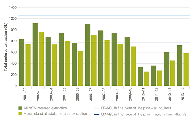
Source: DPI Water data 2015
Notes: The major inland alluvial aquifers are those of the Lower Gwydir, Lower and Upper Namoi, Lower Macquarie, Lower Lachlan, Lower Murrumbidgee and the Lower Murray rivers.
The dark blue line is the long-term average annual extraction limit (LTAAEL) for these major groundwater sources only, which is the level of water that can be extracted annually on a sustainable basis over a longer time frame.
The light blue line is the LTAAEL for all metered extraction in NSW.
Extraction limits are being reduced gradually to align with the LTAAEL by the final year of relevant water sharing plans in 2016–17.
Data for Figure 19.1
Long-term average annual extraction limits
The long-term average annual extraction limit (LTAAEL) is the volume of groundwater that can be extracted sustainably, on an annual average basis over a longer term, from the groundwater sources defined in water sharing plans. It is effectively the plan 'limit'.
Where data is available, the extraction limit is based on numeric models that simulate rainfall and river leakage over a period of 20 to 30 years. In other areas it is based on either the previous history of groundwater extraction or the estimated rainfall recharge expressed as a percentage of annual average rainfall. The portion of recharge not available for extraction is allocated to the environment, as is the average volume of groundwater held in storage to protect significant environmental assets and ensure long-term viability of the groundwater source.
Water sharing plans and extraction levels
To address historical over-allocation, the water sharing plans for the large inland alluvial systems of the Lower Gwydir, Upper and Lower Namoi, Lower Macquarie, Lower Lachlan, Lower Murrumbidgee and the Lower Murray provide for progressive reductions in water allocations over their 10-year terms, down to the predicted sustainable limits of these systems. The implementation of such plans has expanded beyond these six major inland alluvial aquifers, with all inland (Murray–Darling Basin) groundwater sources in NSW now covered by water sharing plans (see Responses section).
The water sharing plans for groundwater ensure that the resource is managed sustainably, so that extraction remains in balance with recharge and groundwater levels do not become depleted, causing unacceptable impacts to the aquifer or GDEs.
Extraction compared to extraction limits
Groundwater use for the period 2013–14 as a percentage of the LTAAEL is shown in Map 19.1. This provides an indication of sustainable use in areas where groundwater use is metered and monitored. With dry conditions and low surface water availability prevailing in most areas, particularly in northern NSW, demand for groundwater was higher, leading to higher extraction levels. The highest percentages of extractions against LTAAEL were from the Lower Gwydir, Lower Namoi and Upper Namoi water sources (between 112% and 127%). If this trend continues in coming years lower annual allocations or 'available water determinations' (AWDs) may be announced.
Extractions above 75% of LTAAEL were also recorded in the Wagga Wagga Alluvium, Peel Alluvium, Upper and Lower Macquarie Alluvium, Lower Murrumbidgee Alluvium (around Hay) and Upper Murray Alluvium (around Howlong).
Map 19.1: Extraction from NSW groundwater aquifers as a percentage of the long-term average annual extraction limit, 2013–14
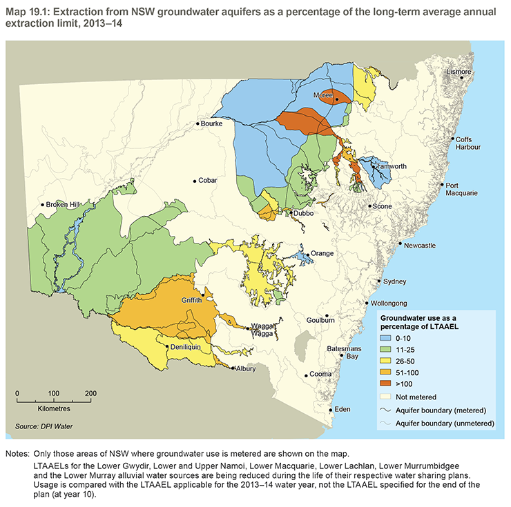
Notes: Only those areas of NSW where groundwater use is metered are shown on the map.
LTAAELs for the Lower Gwydir, Lower and Upper Namoi, Lower Macquarie, Lower Lachlan, Lower Murrumbidgee and the Lower Murray alluvial water sources are being reduced during the life of their respective water sharing plans. Usage is compared with the LTAAEL applicable for the 2013–14 water year, not the LTAAEL specified for the end of the plan (at year 10).
Groundwater-dependent ecosystems
Groundwater-dependent ecosystems (GDEs) are described in water sharing plans for groundwater as 'ecosystems where the species composition or natural functions depend on the availability of groundwater'. The dependence on groundwater may be complete or partial, such as during periods of drought. The degree and nature of the dependency influences the extent to which ecosystems are affected by changes to water quality or quantity in groundwater aquifers.
GDEs occur across a broad range of environments, from highly specialised subterranean ecosystems to more generally occurring terrestrial, aquatic and marine ecosystems. There are two main groupings of GDEs – subsurface ecosystems and surface ecosystems – and seven broad types overall, based on ecological, geomorphic and water chemistry criteria. These are listed below and were described in greater detail under 'Groundwater-dependant ecosystems' in SoE 2012 (EPA 2012).
Subsurface ecosystems
- subsurface phreatic aquifer ecosystem
- karsts and caves
- subsurface baseflow streams.
Surface ecosystems
- surface baseflow streams
- wetlands
- estuarine and near-shore marine ecosystems
- groundwater-dependent or phreatophytic vegetation.
The most significant, diverse and potentially sensitive groundwater-dependent ecosystems and organisms are found in underground springs and cave systems.
Identification of groundwater-dependent ecosystems
Interest in GDEs and their sustainability is relatively recent and little is known about their location or condition (Eamus & Froend 2006). However, since the release of the NSW State Groundwater Dependent Ecosystem Policy (DLWC 2002), the NSW Government has been actively engaged in identifying GDEs across the state, and the number of GDE types has grown as knowledge has improved. Current mapping is still limited and is not yet available statewide, but mapping of GDE extent is complete for coastal NSW except the Greater Sydney area, as well as the Namoi valley. GDEs in the other inland valleys will be mapped over the next three years.
Pressures
Excessive demand and extraction
Reducing the storage levels of an aquifer or the permanent mining of the resource will affect its stability and integrity over the longer term, as well as having permanent consequences for all dependent ecosystems and beneficial uses. There is a risk that competition for groundwater resources can impair the long-term security of these resources.
NSW groundwater sources have been assessed for risk due to groundwater demand using a standard developed under the National Framework for Compliance and Enforcement Systems for Water Resource Management. The outcome of this risk assessment is shown in Map 4.6 in SoE 2012.
The areas at highest risk were characterised by high consumption with entitlements close to or above extraction limits.
Saline intrusion
Where the level of extraction of groundwater is high and the aquifer is overlain by saline aquifers or is located near the coast, there is a risk of saline water intrusion into the depleted aquifer. This will have a detrimental effect on water quality and related uses. The intrusion of sea water is relevant particularly to the coastal sand beds north of Newcastle, which are an important source of water for the Greater Newcastle area.
Studies have recently been completed to assess the risks caused by high volume groundwater extraction on groundwater quality in the six major inland alluvial aquifers. Localised areas of water quality decline have been discovered and strategies are being developed to address those areas of risk.
Coal seam gas
Great care needs to be taken to ensure that mining and coal seam gas developments do not result in permanent damage to aquifers sothe the coal seam gas (CSG) industry in NSW is strictly regulated. All CSG operations require approval from a consent authority and an environment protection licence from the EPA. Both the consent and the licence include legally enforceable conditions intended to protect the environment, including surface and groundwater resources. There is a low risk of enhanced inter-aquifer connectivity, aquifer destruction or surface pollution if a CSG project is operated and managed in accordance with its conditions of approval, its environment protection licence and the codes of practice and guidelines that apply in NSW.
At present the Camden site operated by AGL is the only CSG site in NSW in production. Other projects at Gloucester (AGL) and Narrabri (Santos) are currently in the exploration phase.
Groundwater level and quality are regularly monitored across the state with a network of 4700 state-owned monitoring bores at 2800 sites, with real-time data made available for 390 of these bores on the internet. DPI Water is also enhancing its deep monitoring sites and constructing new bores in groundwater sources that are being actively explored for CSG and mining opportunities in NSW.
Chemical contamination
Groundwater contamination by chemical pollutants can significantly reduce the value of water to users or the environment and increase the cost of water treatment. It may prevent some types of water use altogether. Once an aquifer is polluted, it is extremely difficult and expensive to restore.
Groundwater contamination is largely associated with long-standing existing or former industrial areas and tends to be in urbanised areas concentrated around Sydney, Newcastle and Wollongong.
Climate change
The Sustainable Yields Assessment Project for the Murray–Darling Basin (CSIRO 2008) identified that current and probable future levels of groundwater extraction will have a greater impact on inland aquifer systems than any likely reduction in recharge from rainfall and river systems due to climate change. Along the coast, the potential impacts of sea level rise and climate change on coastal aquifers will be more significant, with saline intrusion on freshwater coastal aquifers affecting associated groundwater-dependent ecosystems.
Responses
Water Management Act 2000
The Water Management Act 2000 requires all groundwater aquifers to be managed sustainably and this is occurring through the implementation of statutory water sharing plans for groundwater.
NSW State Groundwater Dependent Ecosystems Policy
The NSW State Groundwater Dependent Ecosystems Policy (DLWC 2002) provides guidelines on how to protect and manage groundwater-dependent ecosystems. Work is ongoing to establish the location of these ecosystems and how heavily they rely on groundwater.
NSW Aquifer Interference Policy
The NSW Aquifer Interference Policy (DPI 2012) has been developed as a component of the NSW Government's Strategic Regional Land Use Policy. The new policy details how potential impacts to aquifers, such as those posed by mining and CSG activities, should be assessed and licensed to strike a balance between the water requirements of towns, farmers, industry and the environment. This plays an important role in the assessment of proposed mining and CSG developments.
Interim aquifer interference regulation
An interim aquifer interference regulation took effect on 30 June 2011, which requires new mining and petroleum exploration activities that extract more than three megalitres (ML) per year from groundwater sources to hold a water access licence.
Water sharing plans for groundwater
As of July 2015 there are 41 gazetted water sharing plans which cover groundwater sources, including all of inland NSW, with another 12 plans for coastal aquifers expected to be completed by 2016.
The intent of water sharing plans for groundwater is to manage the resource so that extraction remains in balance with the capacity to replenish it over the longer term.
The environmental provisions in the groundwater sharing plans are centred on:
- protecting the long-term storage component of the aquifer
- reserving a proportion of the average annual recharge for the environment.
In some NSW groundwater systems, the level of entitlement was greater than the sustainable yield of the aquifer at the commencement of the water sharing plan. The implementation of water sharing plans for all groundwater sources includes a process to manage groundwater use to align with the sustainable yield of aquifers.
This is being achieved by reducing allocations in the major inland alluvial groundwater sources over the 10-year period of the water sharing plans. Figure 19.2 shows the effect of these reductions in the early years of the plans. Usage in other over-committed groundwater systems is being similarly managed.
Figure 19.2: Entitlements to groundwater under water sharing plans in the major inland alluvial aquifers
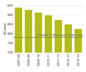
Source: Office of Water data 2011
Data for Figure 19.2
Cap and Pipe the Bores program
Since the 1990s, various programs have been in place to cap and pipe bores across the Great Artesian Basin, which underlies parts of NSW, Queensland, the Northern Territory and South Australia, to reduce water wastage and improve groundwater pressure.
The Cap and Pipe the Bores program provides financial incentives to landholders to offset the cost of rehabilitating bores and installing efficient piped systems to replace open bores. The pipeline systems provide water to properties, prevent large quantities of salt from entering drainage systems, and help drought-proof properties. These measures have produced savings of 78,500 ML per year in the NSW part of the Great Artesian Basin and there has now been an increase in water pressure across the basin. A further joint Australian–NSW Government phase of the program was announced in July 2015.
Aquifer protection and research
Significant effort in groundwater research has occurred over the past three years. With the assistance of industry and government partners, NSW has undertaken studies to better understand the dynamics and chemistry of NSW aquifer systems, and their hydraulic interaction with rivers, and to learn more about groundwater-dependent ecosystems. Some of these studies have been completed and are already influencing decision-making for groundwater management.
Future opportunities
In many groundwater management areas, meter readings are not reported. Current knowledge of groundwater recharge and availability is based on estimates using the limited data available and conceptual models of groundwater recharge. Better monitoring of extraction will improve these models and enable greater accuracy when setting extraction limits.
The connections between groundwater and surface water systems should also be better understood. The potential for holistic management of closely linked systems as a single integrated resource needs further development.
As part of the water sharing plans, the sustainable extraction limit for each water source is set and in the major freshwater aquifers entitlements and extractions are at this level. However, many water sources that are deep or contain brackish groundwater have water that is not yet allocated. A process has been formulated for the controlled allocation of a proportion of this water where its use will not adversely affect surface water flows, other groundwater users or the environment, with three such controlled allocations undertaken so far.
Knowledge of groundwater-dependent ecosystems is still at an early stage and better understanding is needed of their location, characteristics and levels of dependency. Little is also known about the fauna and flora that live within, or are dependent on, groundwater aquifers and this makes it difficult to manage groundwater systems to protect them.
References
CSIRO 2008, Water Availability in the Murray–Darling Basin: A report to the Australian Government from the CSIRO Murray–Darling Basin Sustainable Yields Project, Commonwealth Scientific and Industrial Research Organisation, Canberra [https://publications.csiro.au/rpr/pub?list=SEA&pid=legacy:530] Cited in: Ch 19; Ch 16(1); Ch 16(2); Ch 17
DLWC 2002, The NSW State Groundwater Dependent Ecosystems Policy, Department of Land and Water Conservation, Sydney [www.water.nsw.gov.au/ArticleDocuments/34/groundwater_dependent_ecosystem_policy_300402.pdf.aspx] Cited in: Ch 19(1); Ch 19(2)
DPI 2012, NSW Aquifer Interference Policy, NSW Department of Primary Industries, Sydney [www.water.nsw.gov.au/water-management/law-and-policy] Cited in: Ch 19
EPA 2012, New South Wales State of the Environment 2012, NSW Environment Protection Authority, Sydney [www.epa.nsw.gov.au/soe/soe2012] Cited in: Ch 19; Ch 2; Ch 7; Ch 8; Ch 12(1); Ch 12(2); Ch 13(1); Ch 13(2); Ch 14; Ch 16; Ch 17; Ch 20(1); Ch 20(2)
Eamus, D & Froend, R 2006, 'Groundwater-dependent ecosystems: the where, what and why of GDEs', Australian Journal of Botany, 54(2), pp. 91–96 [dx.doi.org/10.1071/BT06029] Cited in: Ch 19